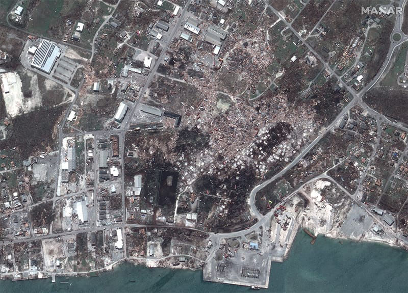
The Open Data program is our mission in action. Maxar supports the greater geospatial community by providing the most accurate data and analytics in times of disaster. Organizations working on the front lines increase their impact and effectiveness by having access to this data.
How many events?
8 events activated in 2019
How many total events?
50 events activated overall
How much data?
Data from 26 countries
How many square km?
295,799 sqkm of imagery
When crises occur, Maxar is committed to supporting the humanitarian community by providing critical and actionable information to assist response efforts. Associated imagery and crowdsourcing layers are released into the public domain under a Creative Commons 4.0 license, allowing for rapid use and easy integration with existing humanitarian response technologies.
As of November 17, 2020, Hurricane Iota is considered the strongest storm to hit Nicaragua in the country’s history and has so far killed six people, according to the Nicaraguan government. More than 400,000 people in Nicaragua have been affected by the storm as it made landfall near Haulover as a Category 4 storm with maximum sustained winds near 155 mph according to the National Hurricane Center. Over 62,000 people in the Central American nation have been moved into government shelters following the storm. Communications is almost non-existent due to blackouts and fallen electrical cables. Hurricane Eta also has devastated Central America, leaving residents to wade through the wreckage of two storms in a matter of weeks. Eta’s landfall was approximately 15 miles away from Iota in the Haulover area and was also a Category 4.
Event | Date | |
---|---|---|
Hurricanes Eta and Iota | Nov. 18, 2020 | Learn more |
Typhoon Vamco | Nov. 12, 2020 | Learn more |
Turkey Earthquake | Nov. 06, 2020 | Learn more |
Typhoon Goni | Nov. 02, 2020 | Learn more |
Mauritius Oil Spill | Oct. 13, 2020 | Learn more |
Hurricane Delta | Oct. 08, 2020 | Learn more |
Oregon Washington Fires | Sept. 16, 2020 | Learn more |
Hurricane Sally | Sept. 15, 2020 | Learn more |
California and Colorado Fires | Sept. 09, 2020 | Learn more |
Ndjamena Chad Flooding | Sept. 05, 2020 | Learn more |
Hurricane Laura | Aug. 26, 2020 | Learn more |
Beirut Explosion | Aug. 04, 2020 | Learn more |
COVID19 | March 11, 2020 | Learn more |
COVID19 Sierra Leone | March 10, 2020 | Learn more |
COVID19 South Sudan | March 10, 2020 | Learn more |
COVID19 Malawi | March 10, 2020 | Learn more |
COVID19 Jamaica | March 10, 2020 | Learn more |
COVID19 Ghana | March 10, 2020 | Learn more |
Typhoon Vongfong | March 10, 2020 | Learn more |
COVID19 Democratic Republic of the Congo | March 10, 2020 | Learn more |
COVID19 Bangladesh | March 10, 2020 | Learn more |
Australia Wildfires | Jan. 15, 2020 | Learn more |
Puerto Rico Earthquake | Jan. 08, 2020 | Learn more |
Event | Date | |
---|---|---|
Kincade Fire | Oct. 20, 2019 | Learn more |
South Sudan Flooding | Aug. 25, 2019 | Learn more |
Midwest Floods | June 01, 2019 | Learn more |
Cyclone Fani | May 02, 2019 | Learn more |
Cyclone Idai | March 24, 2019 | Learn more |
Papua Indonesia Flooding | March 18, 2019 | Learn more |
Event | Date | |
---|---|---|
Sunda Strait Tsunami | Dec. 22, 2018 | Learn more |
Woolsey Fire | Nov. 08, 2018 | Learn more |
California Wildfires | Nov. 01, 2018 | Learn more |
Super Typhoon Yutu | Oct. 24, 2018 | Learn more |
Hurricane Willa | Oct. 23, 2018 | Learn more |
Hurricane Michael | Oct. 10, 2018 | Learn more |
Indonesia Earthquake & Tsunami | Sept. 28, 2018 | Learn more |
Hurricane Florence | Sept. 14, 2018 | Learn more |
Super Typhoon Mangkhut | Sept. 14, 2018 | Learn more |
Flooding in India | Aug. 17, 2018 | Learn more |
Indonesia Earthquake | Aug. 12, 2018 | Learn more |
Myanmar Floods | July 30, 2018 | Learn more |
Carr Wildfire | July 27, 2018 | Learn more |
Lower Puna Volcano | May 03, 2018 | Learn more |
Tropical Cyclone Gita | Feb. 13, 2018 | Learn more |
Event | Date | |
---|---|---|
Southern California Wildfires | Dec. 05, 2017 | Learn more |
Santa Rosa Wildfires | Oct. 08, 2017 | Learn more |
Southern Mexico Earthquake | Sept. 08, 2017 | Learn more |
Hurricane Irma | Sept. 06, 2017 | Learn more |
Hurricane Harvey | Aug. 25, 2017 | Learn more |
Sierra Leone Mudslide | Aug. 14, 2017 | Learn more |
Portugal Wildfires | June 17, 2017 | Learn more |
Event | Date | |
---|---|---|
Hurricane Matthew | Oct. 09, 2016 | Learn more |
Ecuador Earthquake | April 16, 2016 | Learn more |
Event | Date | |
---|---|---|
Pinery Bushfires | Nov. 25, 2015 | Learn more |
Nepal Earthquake | April 25, 2015 | Learn more |
Event | Date | |
---|---|---|
Moore Tornado | May 20, 2013 | Learn more |
Event | Date | |
---|---|---|
Tuscaloosa Tornado | April 27, 2011 | Learn more |
Joplin Tornado | March 22, 2011 | Learn more |
Event | Date | |
---|---|---|
Haiti Earthquake | Jan. 12, 2010 | Learn more |
Our Program Partners use, access and champion the Open Data Program. They provide feedback on how the data and program are supporting their emergency response data needs, disseminate the data to those who can use it the most, request activations for events. Without our Program Partners, the Open Data Program would not be as impactful as it is today.
Without Maxar as key partner providing satellite imagery, there would not be HOT as we know it.
This initiative underlines the trusted partnership between UNOOSA and Maxar in the area of geospatial information and analytics as the rapid availability of data is essential for a successful response to such a devastating event like the earthquake in Ecuador