
Wireless network planning
Maxar is the trusted geospatial partner for many of the world’s leading telecommunications companies. We provide the customized data, analysis and expertise needed to create accurate location intelligence.
Location intelligence for the networks of tomorrow
Cities are rapidly growing—as are customer expectations around wireless connectivity and signal reliability. The networks of tomorrow will rely on a signal so sensitive it can be blocked by the palm of your hand, making network planning even more complicated.
Network solutions are only as reliable as the data used to plan them. Maxar Intelligence delivers near real-time geodata and flexible platforms to help network operators maintain superiority in existing markets and roll out in new markets faster than the competition.
See the differenceWe used to rely on lower quality clutter data in the New York area. With this data, 60% of all our planned links failed when they were checked by our surveyors. Now, thanks to the accurate and complete representation of buildings and foliage in the [Maxar 3D data], we are able to confidently reject blocked links and pick the clear links, all within our virtual desk plan. Thanks to this high-quality clutter height data, we have seen a 98% decrease in false positives.
Maxar is the trusted geospatial partner for many of the world’s leading telecommunications companies. We provide the customized data, analysis and expertise needed to create accurate location intelligence.

Streamline your workflow and improve propagation models with fresh satellite imagery-derived geodata. We offer advanced off-the-shelf geodata or reliable source data to build your own.

Leverage our robust analytics platform to identify features, extract information and build your own unique data solutions. We can help you integrate IoT sensor data and networks to power technology that brings location intelligence to end users.

As an imagery source, we can access and process content faster—helping you get the derived data layers you need sooner. Industry-leading 30 cm class resolution leads to more accurate results, reducing cost and time associated with iteration.
Foundational data for reliable maps
Learn moreVectorized 3D buildings, clutter height data and vegetation layers ideal for small-cell and macro-cell deployments over large or dense areas
Learn moreA comprehensive database of change to help you identify rapid infrastructure development available via the Maxar® Geospatial Platform.
Learn more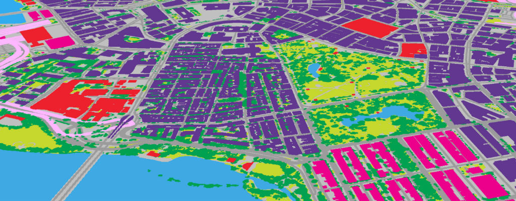
Are one-time geodata purchases slowing you down? Keep pace with rapid change affecting your network.
Explore advanced geodata to see how better data helps you maintain your advantage.
Request a demo