Solutions for U.S. Government

Unparalleled speed and accuracy for national security. The strength of combined offerings for next-gen missions.

Advancing National Security And Global Awareness

Trusted, rapid and precise geospatial intelligence (GEOINT) for confident decision-making is essential to meet new threats, respond to adversaries and react to global change.
 

Technologies that enable rapid, confident decision-making from space-based information are increasingly important in the joint operational environment of the future.

Maxar Intelligence’s Solutions In Action

High-resolution commercial satellite imagery

Maxar provides 90% of the commercial satellite imagery used to create foundational GEOINT for the U.S. government.  Maxar continues its trusted partnership with the National Reconnaissance Office to enable U.S. government users to make confident and informed decisions using reliable high-resolution commercial satellite imagery for ongoing mission-critical support. 

Learn more about Electro-Optical Commercial Layer

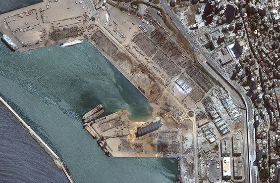
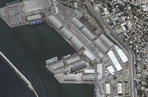
On-demand access to multisource imagery

Maxar’s Global Enhanced GEOINT Delivery (GEGD) program enables the National Geospatial-Intelligence Agency (NGA) to provide U.S. government users with online and offline, on-demand access to the world’s highest resolution commercial imagery. Users have access to current Maxar and third-party imagery as well as billions of square kilometers of archived imagery for time-sensitive, mission-critical planning and operations.

If you support a government mission, you may be authorized to access GEGD. Connect with your government point of contact to determine eligibility.

Learn more about GEGD
After Beirut explosion, August 5, 2020
Before Beirut explosion, June 9, 2020

One World Terrain

Maxar is the prime contractor for the U.S. Army’s One World Terrain (OWT) program, which delivers 3D terrain and information services that support a fully accessible virtual representation of Earth through the U.S. Army network.

Learn more about OWT

Big data analytics

In partnership with NGA, Maxar develops and operates a mission-critical analytic system relied on by thousands of U.S. DOD and intelligence community (IC) users. This system leverages geospatial tools to manage and exploit hundreds of data feeds, reducing analysis time from hours to minutes.

Learn more about big data

NGA’s open mapping platform

The National System for Geospatial Intelligence Open Mapping Enclave (NOME) platform enables a community of vetted U.S. government users to create and update geospatial features in a crowdsourced “living map.” NOME was initially developed to support NGA’s foundation mapping mission, but the platform emerged as a powerful tool to perform unclassified mission support remotely throughout the COVID-19 pandemic.

Learn more about NOME

Cloud-based GEOINT

Maxar’s Red Wing architecture, developed for the Air Force Research Laboratory, enables geospatial analysts to focus on addressing some of the most challenging intelligence problems by automating time-consuming workflows.

Learn more about Red Wing

Insight from space

Maxar imagery provides insight not only for DOD and IC customers but also to major news outlets seeking ground truth in dangerous or hard-to-reach locations. Aviation Week named Maxar a 2022 Laureate Award Winner in the Space category for our contributions to sharing data to assist Ukraine and reveal war crimes and human rights violations.

Read the article

Tactical imagery access

The highly portable Maxar-built U.S. Army Remote Ground Terminal (RGT) provides critical GEOINT to warfighters in remote locations.

Learn more about RGT

Superior Earth intelligence and mission architecture

Maxar enables the U.S. and its allies to better monitor, understand and respond to global events, deter threats and ensure global security. Together, the many elements of Maxar can help the U.S. military and IC maintain decision advantage and rapidly identify and predict change.

Start a conversation

Having the right solution for your mission, team and budget makes all the difference. We can help you find the right fit for your objectives.

Contact Sales